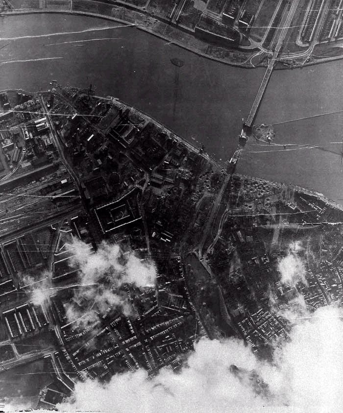
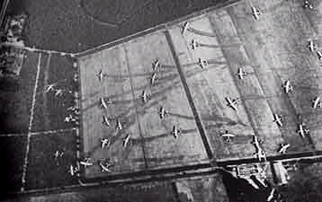
| Arnhem After.jpg | ||
| Description: |
|
|
| Filesize: | 157.28 KB | |
| Viewed: | 22414 Time(s) | |
 |
||
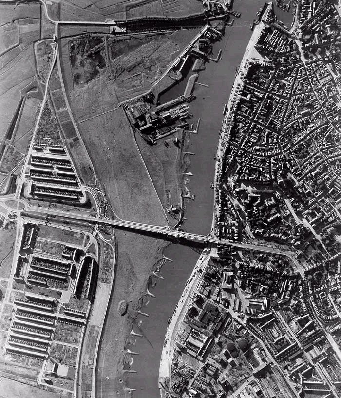
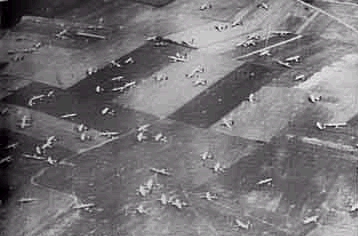
| Arnhem Before.jpg | ||
| Description: |
|
|
| Filesize: | 229.07 KB | |
| Viewed: | 22414 Time(s) | |
 |
||
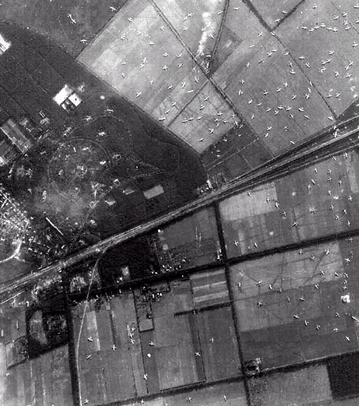
| Gliders West of Wolfhezen.jpg | ||
| Description: |
|
|
| Filesize: | 253.99 KB | |
| Viewed: | 22414 Time(s) | |
 |
||
| robg wrote: |
|
Hy Buck,
I have some pictures, taken from a book " It never snows in september" that may help you. How can I send them to you ? How can I add them to close combat camera ? Regards |
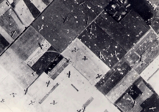
| 82nd Airborne Landing Zone T Groesbeek.jpg | ||
| Description: |
|
|
| Filesize: | 203.57 KB | |
| Viewed: | 22374 Time(s) | |
 |
||
| unkown LZ outside of Arnhem.jpg | ||
| Description: |
|
|
| Filesize: | 68.14 KB | |
| Viewed: | 22373 Time(s) | |
 |
||
| unkown LZ outside of Arnhem2.jpg | ||
| Description: |
|
|
| Filesize: | 65.72 KB | |
| Viewed: | 22373 Time(s) | |
 |
||
| Nembo wrote: |
| Heres some more I found after a quick Google search. |
| Buck_Compton wrote: |
|
Hey guys here is a list of maps i chose to include in to the mod.
Arnhem Area: 01 Ginkelse Heath (DZ-Y) 02 Reyers Farm (LZ-S) + 03 Renkumse Heath (DZ-X+ LZ-Z+) 04 Railwaybridge + 05 Oosterbeek (Hartenstein HQ) - 06 St. Elizabeth Hospital - 07 Arnhem Bridge + 08 Arnhem east 09 Arnhem North The Island: 10 Driel ferry Site + 11 Polish LZ - 12 Elst - 12 Bemmel 13 82nd LZ north of the Waal 14 Fort Hof van Holland 15 Oosterhout + Nijmegen Area: 16 Nijmegen Bridge + 17 Nijmegen outskirts 18 Honinghutje + 19 Hatert 20 Malden 21 Heumen + 22 Grave Bridge + 23 Grave LZ-O 24 Groesbeek LZ-T + 25 Groesbeek LZ-n + Neerpelt Area: 26 Joe's Bridge - 27 La Kolonie - 28 Valkenswaard 29 Aalst - Eindhoven Area: 30 Veldhoven 31 Eindhoven 32 Best Bridge - 33 Son Bridge + 34 Nuenen 35 DZ Son (DZ-W) - 36 DZ Veghel (DZ-A) 37 St Oedenrode 38 Veghel bridge + 39 Veghel + 41 Hells highway (lochtenburg) - 42 Erp 43 Eerde - - = Still need better Photo's aireals and maps of the area. + = Map is actually in progress = No info on that map at all Now i have a request for all you guys; i need all you can find about the maps as i stated them here Aerials, maps, overviews photographs...all that you got hidden out there and can find. Here is a link to our Combat Camera: http://www.closecombatseries.net/CCS/modules.php?name=coppermine&file=thumbnails&album=115&cat=0&page=1 Cheers Buck |
| nomada_lenin wrote: |
|
hi buck.
i have "operation market garden" book by osprey military and have some air photos maybe you can use it |
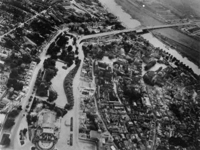
| Arnhem Bridge.jpg | ||
| Description: |
|
|
| Filesize: | 52.92 KB | |
| Viewed: | 21948 Time(s) | |
 |
||
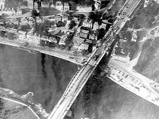
| Arnhem Bridge During Battle.jpg | ||
| Description: |
|
|
| Filesize: | 96.79 KB | |
| Viewed: | 21948 Time(s) | |
 |
||
| Nembo wrote: |
|
Heres a website not fully functional yet but looks good.
http://www.evidenceincamera.co.uk/ Don't know but this might help also. https://www.britishpathe.com/ |
| Nembo wrote: |
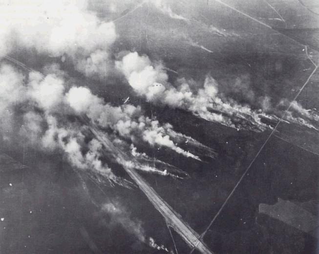
| Sorry should have thought a little more. I'll delete any of the photos or all from the thread if you want. I have one of Ginkel Heath (DZ-Y) its sort of hard to tell where the DZ is because of fires and the fact that the photo was taken just minutes before the paratroopers landed. Do you want it? |
| Ginkel Heath DZ-Y.JPG | ||
| Description: |
|
|
| Filesize: | 41.69 KB | |
| Viewed: | 21426 Time(s) | |
 |
||
| Nembo wrote: |
| Here it is. Hope it helps. |
| nomada_lenin wrote: |
|
hi buck
finally i could found my book. the pohotos are x-ray landing zone and arhen brigde but you have it nimega i think that this photo is the best you can see the two brigdes but your map is in progress. do you want it? the landing zone in the sonsche area but i thi9nk that is the the same. |
| Tejszd wrote: |
| Glad to hear you are still making progress... |
output generated using printer-friendly topic mod. All times are GMT