—
| platoon_michael wrote: |
|
Hey Jager If your interested send me a PM
Other wise I would assume your not interested. |
Hi,
Of course I am interested!
The only problem is that I really don't understand anything with the files included in your folders!!
What I would like to know is:
1) What kind of graphics do I need? Is it comparable to the graphics I made with Stratedit for CC5 (I can easily remove one map)
2) If there are some others, can you please clearly eplain what I need to paint?
Of course, I am ready to send you all these graphics if you can make the CC4.exe and the stratamap rapidly with that.
Please let me know.
Cheers
PJ
—
Hello Jager,
You can send me the files (platoon_michael@hotmail.com)
My e-mail account has been upgraded to hold more so I assume it would accept the file sizes you intent to send.
You would however need to redo your original strategic map to be able to fit on a 800X600 .tga as you know CCIV doesnt have a scrolling strat map.I've tried a few times just rescaling the Bloddy Omaha mod and never really liked the results so I do sugest redoing it to fit properly.Have another look at the image posted in this forum as it is really even smaller than that with having the calander and the bottom border.
Note:
The calander can be relocated using Mafi's RTBTool
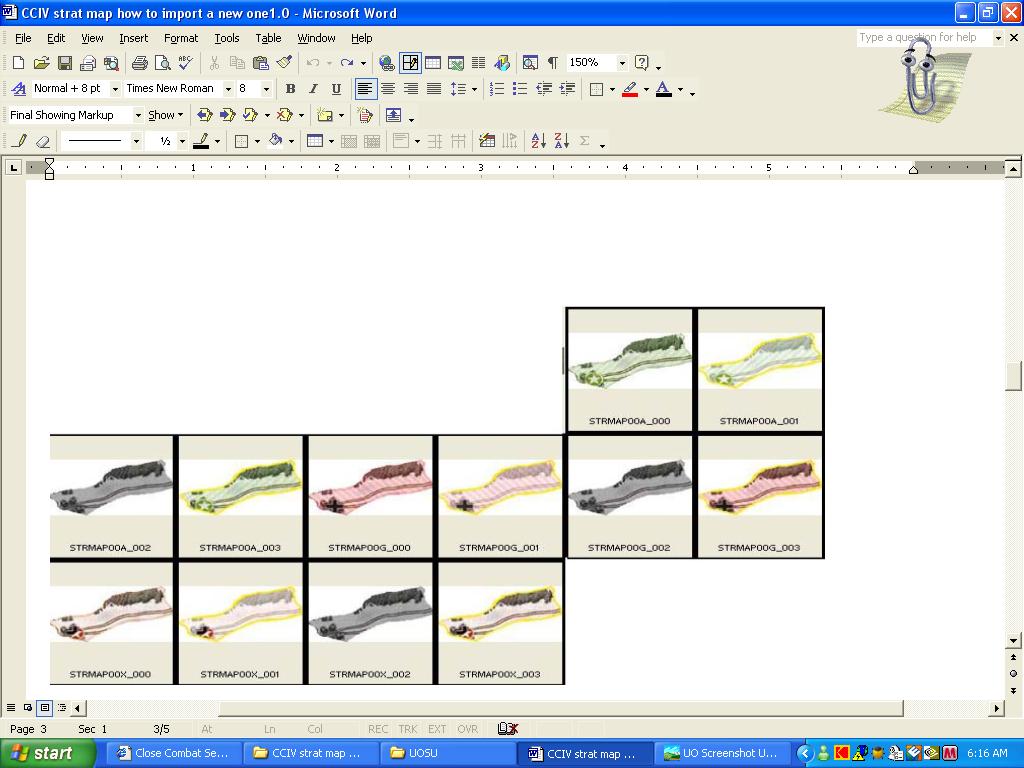
When viewing the STRMAP filters inside the scrngdg there are 4 filters for each manner of the game I.E. 1 set for playing as the Allies
1 set for when you play as Germans and 1 set for contested.
The manner in which they work for a grand campaign and Operations in game is as follows.
STRMAP00A_000 is your base image displayed for an Allied controlled map
STRMAP00A_001 is the images displayed when you mouse over and click on a map town.
STRMAP00A_002 is the shaded non-used image that is displayed for when the user is playing an Operation
STRMAP00A_003 is the highlighted mouse over.
Their are also 4 images to be created for contested maps and 4 more for German help maps.
A total of 12 images for each town need to be created.However the non-shadded image can be used 3 times over.
I strongly suggest no 1/2 pixels when cutting the strat map down for individuale use on the strat map.So lets say the image for map A is 65X70 not 65.5 X 70.5
I don't know if the debrief strat map is the same size in CCIV as in CCV.So I don't know off the top of my head if those images would need to be redone.But that can be done/figured out later
I would also need a complete list of map names and their connections.
CCIV has 81 connections for it's strategic map.
| UO0002.jpg | ||
| Description: |
|
|
| Filesize: | 98.81 KB | |
| Viewed: | 2793 Time(s) | |
 |
||
—
Here's proof again it can be done.
I also know Aetius has created one for Crete.(I hope he doesnt mind me mentioning that)
And what I always thought would be some maybe cool ideas for a strat map.
http://www.closecombat.org/forums/showthread.php?p=105907#post105907
output generated using printer-friendly topic mod. All times are GMT