Posted: Sun Feb 16, 2014 12:51 pm Post subject: How to fix elevation LOS problems
How to correct elevation LOS errors in WaR and other Matrix CC games.
Part 1.
This type of errors comes from to large differences in the elevations on a map. IE: the highest points and the lower arias of a map.
Okay, I dont have WaR installed and I don’t use Mafis fancy tools. I use 3C Cartographer but I guess Mafis tools make the same thing even more easy.
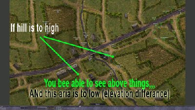
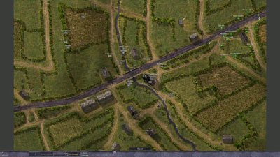
If we look at the map it looks like this:
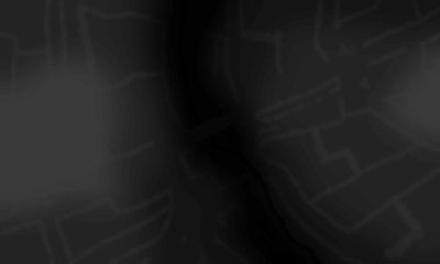
And if we translate that into a grapix image that depicts the elevation it look like this:
The higher the ground is the brighter (more white) the image is, the darker the lower the ground is, a mountain is whyite, a pit is black.. etc..
elevation explain (kopia)2.jpg
Description:
Filesize:
142.16 KB
Viewed:
426 Time(s)
_raids.jpg
Description:
Filesize:
54.82 KB
Viewed:
434 Time(s)
___Elevation_0001.jpg
Description:
Filesize:
59.3 KB
Viewed:
429 Time(s)
Last edited by AT_Stalky on Sun Feb 16, 2014 3:29 pm; edited 3 times in total
Posted: Sun Feb 16, 2014 1:20 pm Post subject: Re: How to fix elevation LOS problems
Part 2:
First backup all the map data files before making anything…
Start up the map coding tool, in this case its 3C, Cartographer.
1. Load the right element.ini file, etc. (Don’t know if it really matter what .ini when its just elevations that is to be adjusted)
2. File -> “Open image”, load the image, “abc.bgm” .
3. File -> “Open txt”, load the txt file, in this case “abc.txt”
4. Now we are to generate a small image of the heights of this map. Import/Export -> Export --> Elevation bitmap (small).. name the image “abc.tga”
Now you have the elevation as an image.
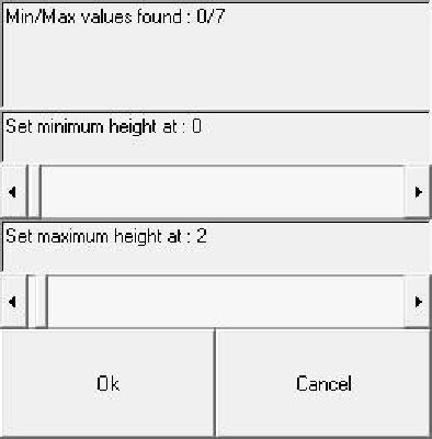
5. Now we are to load the abc.tga image, Import/Export -> Import -- > Elevation bitmap (Small).. Load the abc.tga you just made.
Now you get an option, the first slide-bar is set minimum height, and the second set maximum height. Its straightforward, set small hight difference to start with. In this case minimum at 1, and maximum at a value, for example "6"…
6. Click “OK”
7. We now need to create 2 new files.
8. File -> Save txt… Name the new txt file to abc.txt
9. Import/Export -> Export --> Lose-file…. Name the file abc.los This is a slow process, takes many minutes to generate this file.
10. after several minuts, its done..
11. Take the 2 new files, abc.txt and abc.los and replace the old files in the War map folder.
Test it.
Make just one map at the time, test it and right click on the map to see the actual heights, and move units there and actually see that the selected heights will give the LOS that are inline with the hight differances.. It’s a long time since I used this tool, and I believe that its small differences in heights that will give the best results for most maps. That’s it…
See if that does it.
After geting into this, I belive you can fix all the 64 maps in a couple of houres.
Posted: Mon Feb 17, 2014 4:41 pm Post subject: Re: How to fix elevation LOS problems
Thanks for the tutorial Stalky. Bear in mind that when coding floors or other flat surfaces you need to code the heights of those elements separately. For instance the LOS from single storey homes may be blocked by the height of the adjacent elements.
Posted: Mon Feb 17, 2014 5:18 pm Post subject: Re: How to fix elevation LOS problems
Yes, thats correct, the floors shold be made flat manually if one code a map from scratch..
Though this should not be a problem in this case. As its a totorial how to adjust the hight differances on already excisting maps, thus, the floors shold already be flat (given that the original coder made the floors flat that is), and there for they will remain flat just at another hight..
Posted: Wed Feb 26, 2014 5:01 pm Post subject: Re: How to fix elevation LOS problems
1) The txt file is the file in your map folder, it has the same name as the map, same name as .bgm.. Or you mean, how you crate a new txt after u has made the elevation adjustments?
2) I may be wrong here, but Im not even sure you need a new element file for adjusting only elevations. As its only the elevation value of the ground that is to be remade, and that value is in the maps .txt file. Try without… I used the CC5 .ini.. However, im sure there’s someone here who has made a War/Tld .ini file. Maybe, make a request for it in the mod forum?
Or, does mafis tool have a similar function (export elevation image / import elevation image, and set lowest, and highest points) as described in the guide above?
You cannot post new topics in this forum You cannot reply to topics in this forum You cannot edit your posts in this forum You cannot delete your posts in this forum You cannot vote in polls in this forum You cannot attach files in this forum You can download files in this forum
In August of 2004, Zappi, Homba, Bambam887, RedScorpion and MOOXE all pitched
in to create this Close Combat site. I would to thank all the people who have visited
and found this site to thier liking. I hope you had time to check out some
of the great Close Combat mods and our forums. I'd also like to thank
all the members of our volunteer staff that have helped over
the years, and all our users that contributed to this site!