bux

Rep: 50.2  
votes: 2
|
 Posted: Sat Apr 01, 2017 8:20 pm Post subject: My first mod for GTC: Alpine Insurrection Posted: Sat Apr 01, 2017 8:20 pm Post subject: My first mod for GTC: Alpine Insurrection |
 |
|
Hello,
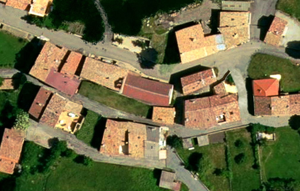
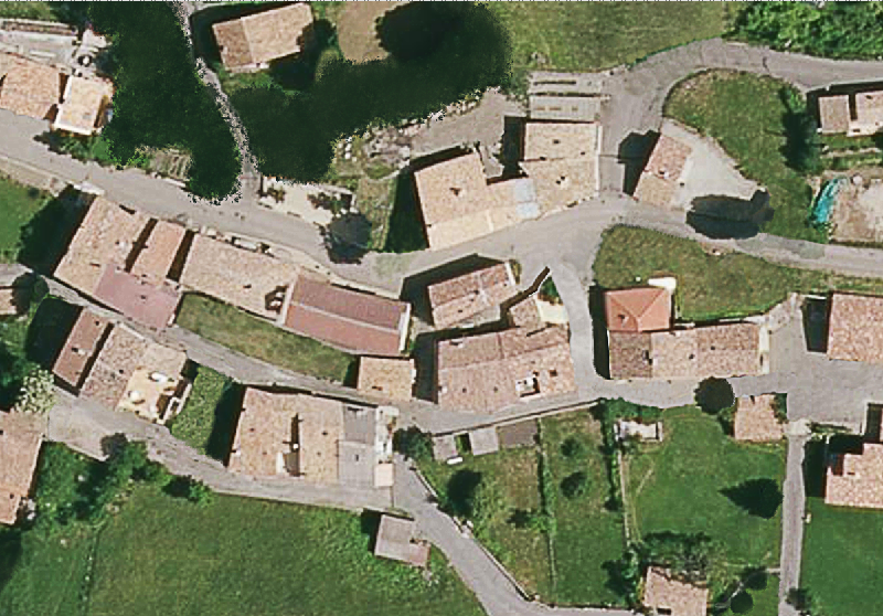
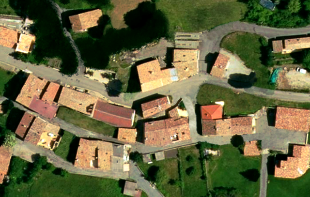
After some days of map editing, i can release the first playbale version of map. The map is based on IGN photo (Institut national de l'information géographique et forestière) of little town in south Alpes mountain range.
My objective is to build a little campain/operation with few maps like that.
Edit: Two maps are now available
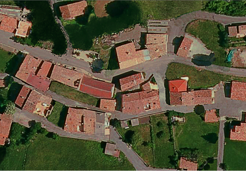
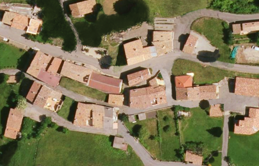
Preview:
Village mini:

Village Elevation:

Bastide mini:

Bastide Elevation (some tiny bug in elevation, will be fixed in next release):

You can download .rar pack here: http://sk.bux.fr/bux/cc/AlpineInsurrection_0.2.1.rar (compressed folder is a folder to place in MODS folder of JSGME).
To play it, play "Alpine insurection" campain.
I would be happy to receive note or advices.
|
Last edited by bux on Mon May 01, 2017 6:49 pm; edited 4 times in total |
|
| Back to top |
|
| |
|
|
mick_xe5

Rep: 19.4
votes: 5
|
| Posted: Sat Apr 01, 2017 10:14 pm Post subject: Re: My first map for GTC: Alpine Insurrection |
|
|
| Downloading now. Did you use digital elevation data or code the elevation manually?
|
|
|
| Back to top |
|
| |
ScnelleMeyer

Rep: 191.3
votes: 18
|
| Posted: Sun Apr 02, 2017 12:27 am Post subject: Re: My first map for GTC: Alpine Insurrection |
|
|
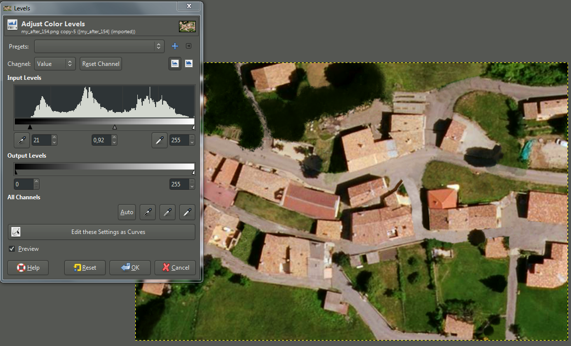
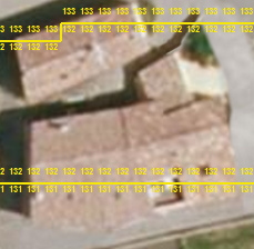
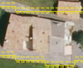
Congratulation on your first released map. - It is hard work making ones first map!
I have always been sceptical about photorealistic maps in Close Combat, but I went ahead and tried a battle on your map.
I am suprised to say that I found it to be quite pleasing graphics wise and the all natural tree placement and buildings make it interesting to play.
- Noticed the coding or graphics doesnt tell you how many floors are in the buildings. - Would be nice if coding and and numbers could be implemented.
- I think the colors directly from the satelite imagery is too de-saturated - too washed out - especially on buildings. And shadows are too dark making too high contrast with surrounding terrain for my taste.
The de-saturated colors on buildings someplaces makes it hard to see where the building roof line is.
I had to check for myself if this could be adjusted somewhat in Photoshop. - Below is my result after quickly using adjustment layers and adjusting some of the shadows.
| Description: |
|
| Filesize: |
1.29 MB |
| Viewed: |
14420 Time(s) |

|
| Description: |
|
| Filesize: |
1.21 MB |
| Viewed: |
14421 Time(s) |

|
|
|
|
| Back to top |
|
| |
platoon_michael

Rep: 56.2
votes: 25
|
| Posted: Sun Apr 02, 2017 9:36 am Post subject: Re: My first map for GTC: Alpine Insurrection |
|
|
| Google Roofs....And Google Maps Suck!
|
|
|
| Back to top |
|
| |
ScnelleMeyer
Rep: 191.3
votes: 18
|
| Posted: Sun Apr 02, 2017 11:27 am Post subject: Re: My first map for GTC: Alpine Insurrection |
|
|
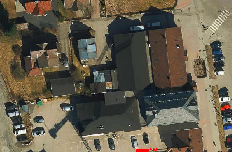
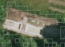
Did some more testing on this concept. This time using aerial photos from an online free map service.
Map picture is a screencapture that was edited quickly using adjustment layers and sharpened using High-pass filter on low setting.
This shot is scaled to 8 pixels pr meter as PITF/GTC - The Stug is 10pixels pr. meter scale.
How about a Platoon attack on a small map like this? - Even the AI would give opposition here given the right teams:)
| Description: |
|
| Filesize: |
680.81 KB |
| Viewed: |
14382 Time(s) |
|
|
|
|
| Back to top |
|
| |
bux
Rep: 50.2
votes: 2
|
| Posted: Sun Apr 02, 2017 12:41 pm Post subject: Re: My first map for GTC: Alpine Insurrection |
|
|
Thank's for your times.
My first goal is to build mini campain for friends who lives in a little valley with two little town (the map is one of these).
| Quote:
|
|
Did you use digital elevation data or code the elevation manually?
|
Manually. I know personally the town and topographic map help me.
| Quote:
|
|
I am suprised to say that I found it to be quite pleasing graphics wise and the all natural tree placement and buildings make it interesting to play.
|
Happy to read that  I think about create map from scratch, but i'm very limited into graphic edition. I can try it one day. I think about create map from scratch, but i'm very limited into graphic edition. I can try it one day.
| Quote:
|
|
I think the colors directly from the satelite imagery is too de-saturated - too washed out - especially on buildings
|
Il will try to adjust it like you, thank's for advice. EDIT: Tried without render like you :/
| Quote:
|
|
Google Roofs....And Google Maps Suck!
|
In fact these photographies are taken by plane (Beechcraft King Air 200). 
|
Last edited by bux on Sun Apr 02, 2017 7:16 pm; edited 1 time in total |
|
| Back to top |
|
| |
bux
Rep: 50.2
votes: 2
|
| Posted: Sun Apr 02, 2017 6:22 pm Post subject: Re: My first map for GTC: Alpine Insurrection |
|
|
Forgotten question:
| Quote:
|
|
- Noticed the coding or graphics doesnt tell you how many floors are in the buildings. - Would be nice if coding and and numbers could be implemented.
|
Exact. Actually all buildings are only one floor. I have to go in real town to check it again.
|
|
|
| Back to top |
|
| |
ScnelleMeyer
Rep: 191.3
votes: 18
|
| Posted: Sun Apr 02, 2017 6:45 pm Post subject: Re: My first map for GTC: Alpine Insurrection |
|
|
| Google streetview can be your friend:)
|
|
|
| Back to top |
|
| |
bux
Rep: 50.2
votes: 2
|
| Posted: Mon Apr 03, 2017 12:28 pm Post subject: Re: My first map for GTC: Alpine Insurrection |
|
|
Good idea !
| Quote:
|
|
I think the colors directly from the satelite imagery is too de-saturated - too washed out - especially on buildings
|
(I work with GIMP) I try iy but i'm not satisfied by result. Your result is better than mine. I change luminosity, constrast, and saturation but grass is fluorescent :/
|
|
|
| Back to top |
|
| |
ScnelleMeyer
Rep: 191.3
votes: 18
|
| Posted: Mon Apr 03, 2017 3:05 pm Post subject: Re: My first map for GTC: Alpine Insurrection |
|
|
Ok I did this with Photoshop, but let me try to explain it for Gimp as best I can.
Try something like this or adjust it to whatever you think looks good:
Start by sharpening the image using a High pass filter - There is a Plugin for Gimp that can be downloaded and installed. I find this the best form of sharpening.
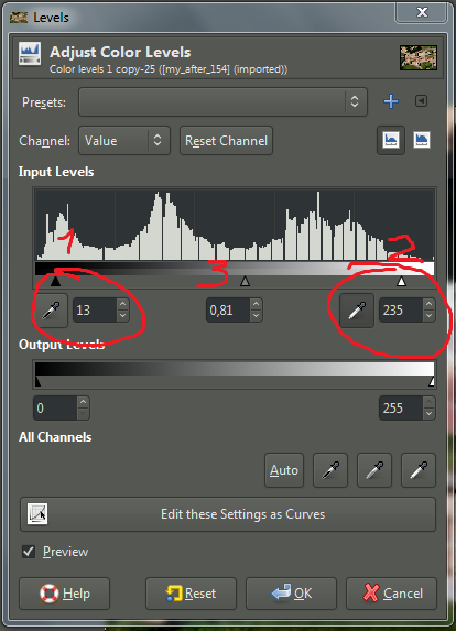
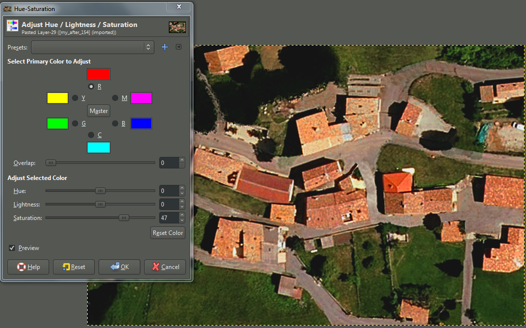
1. COLORS - HUE/SATURATION: +20 Saturation / -10 Lightness
2. Adjust red color by using COLORS - LEVELS - RED CHANNEL. -Might check out the Blue and Green channel too. - I am not so familiar with gimp controls for the levels so I could not get a very good result, but I am sure with more time to learn it it could be similar as Photoshop result.
This video explains some of the color levels usage in Gimp.
https://www.youtube.com/watch?v=qwXAHhcRchQ
3. COLORS - LEVELS Input level to 15 on the Dark side.
4. COLORS - BRIGHTNESS/CONTRAST to brightness 4 / Contrast 10
5. Color filled all map with this green: 52643e set at 25% in layermode Color burn. - Could use other colors too -use one that suits the image - this is to blend everything together.
There are many ways to reach the image you want, but I think this is a good start for your map. - But YOU are the artist and you decide what looks good on your map:)
|
|
|
| Back to top |
|
| |
bux
Rep: 50.2
votes: 2
|
| Posted: Tue Apr 04, 2017 7:25 pm Post subject: Re: My first map for GTC: Alpine Insurrection |
|
|
Thank's for how to ! It's not easy for beginner like me :p
I success with steps 1, 2, 3, 4. But don't found "layermode Color burn" of bucket fill tool. My actual result:
| Description: |
|
| Filesize: |
1.21 MB |
| Viewed: |
14220 Time(s) |
|
| Description: |
|
| Filesize: |
700.6 KB |
| Viewed: |
14220 Time(s) |
|
| Description: |
|
| Filesize: |
1.29 MB |
| Viewed: |
14220 Time(s) |
|
|
|
|
| Back to top |
|
| |
ScnelleMeyer
Rep: 191.3
votes: 18
|
| Posted: Tue Apr 04, 2017 8:55 pm Post subject: Re: My first map for GTC: Alpine Insurrection |
|
|
Very nice Bux -Well done! - I think your map image now has a lot better colors. - But did you sharpen the image ?
To follow up a bit on my last post I have tested some more with Gimp using your last after photo.
Here are some pictures: - Remember - you decide whats looking best to your eyes:)
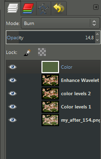
Color Burn is just called Burn in Gimp. Sorry about that. - You can see it is the layer MODE in the picture below - Not related to the Bucket tool.
I fill with bucket , THEN adjust layer mode and opacity percentage.
Hope this helps. - I know it is hard - I have learned this the long way myself:)
| Description: |
| Here adjusting dark side and then center slider. |
|
| Filesize: |
1.17 MB |
| Viewed: |
14195 Time(s) |
|
| Description: |
| Pick lightest and darkest points on image - then adjust center slider until you are happy |
|
| Filesize: |
62.87 KB |
| Viewed: |
14195 Time(s) |
|
| Description: |
| This might be too much sharpening.. test it! |
|
| Filesize: |
1.19 MB |
| Viewed: |
14195 Time(s) |
|
| Description: |
|
| Filesize: |
20.09 KB |
| Viewed: |
14195 Time(s) |
|
|
|
|
| Back to top |
|
| |
ScnelleMeyer
Rep: 191.3
votes: 18
|
| Posted: Tue Apr 04, 2017 9:22 pm Post subject: Re: My first map for GTC: Alpine Insurrection |
|
|
And this adjustment for colors - I found it now:)
| Description: |
|
| Filesize: |
992.01 KB |
| Viewed: |
14188 Time(s) |
|
|
|
|
| Back to top |
|
| |
mick_xe5
Rep: 19.4
votes: 5
|
| Posted: Thu Apr 06, 2017 12:32 am Post subject: Re: My first map for GTC: Alpine Insurrection |
|
|
Some general observations -
tanks need 3 elements of passable terrain between obstacles
some of the bldg shadows on your map look to be at least 2 stories high
areas like the top left are rough enough to be coded as high grass instead of grass field
any foliage that casts even a tiny shadow should be coded as something other than grass (brush, bush etc)
places where there is a distinctive change between the terrain texture usually indicate a fenceline
I see a number of empty pools or water storage sumps
Code the rows of harvested hay as fodder stacks
more terrain types is better = if it looks like a unique object on the map try to give it a unique element type
You have mostly avoided putting bldgs on a slope, a very common mistake. What happens when you do is this...

...which can cause weird effects like units having fire fights through the roof. The steeper the slope a bldg is placed on the worse these effects
Am curious where this map is in Europe? Looking forward to v0.2
|
|
|
| Back to top |
|
| |
bux
Rep: 50.2
votes: 2
|
| Posted: Thu Apr 06, 2017 8:19 pm Post subject: Re: My first map for GTC: Alpine Insurrection |
|
|
Thank you all for your tips and advice ! It is a real pleasure to start close combat modding with your help !
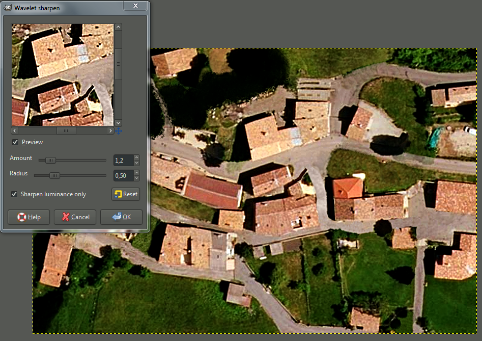
I success with the burn green color, brightness and contrast adjustments. I don't apply yet wavelet sharpen, i installed this plugin but i don't know where is the menu  . There is the actual result in attachement. . There is the actual result in attachement.
| Quote:
|
|
tanks need 3 elements of passable terrain between obstacles
|
Okay, i'm changing that where it is possible.
| Quote:
|
|
some of the bldg shadows on your map look to be at least 2 stories high
|
You're right. I will change wall, floor etc ... I only need to use wall/floor/... marked with L2, L3, etc right ? No need to set elevation ?
| Quote:
|
|
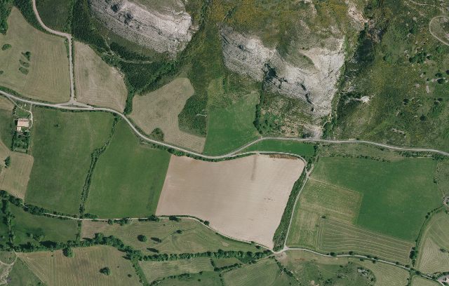
areas like the top left are rough enough to be coded as high grass instead of grass field
|
Okay. This field (top left) is actually dry grass (25cm max). But with grass field soldier look like unable to hide. I will replace like you said.
| Quote:
|
|
any foliage that casts even a tiny shadow should be coded as something other than grass (brush, bush etc)
|
I will place more brush and bushs to.
| Quote:
|
|
I see a number of empty pools or water storage sumps
|
You speak about that (see attached w.jpg file) ? I think it is wastewater treatment plant. I will set deep water on it.
| Quote:
|
|
Code the rows of harvested hay as fodder stacks. more terrain types is better = if it looks like a unique object on the map try to give it a unique element type
|
Okay :)
| Quote:
|
|
You have mostly avoided putting bldgs on a slope, a very common mistake. What happens when you do is this... ...which can cause weird effects like units having fire fights through the roof. The steeper the slope a bldg is placed on the worse these effects
|
Sorry for my english ... So i need to prevent building on elevation "separation" like this (attachement prevent.jpg) or like this (separation.jpg) ?
| Quote:
|
|
Am curious where this map is in Europe? Looking forward to v0.2
|
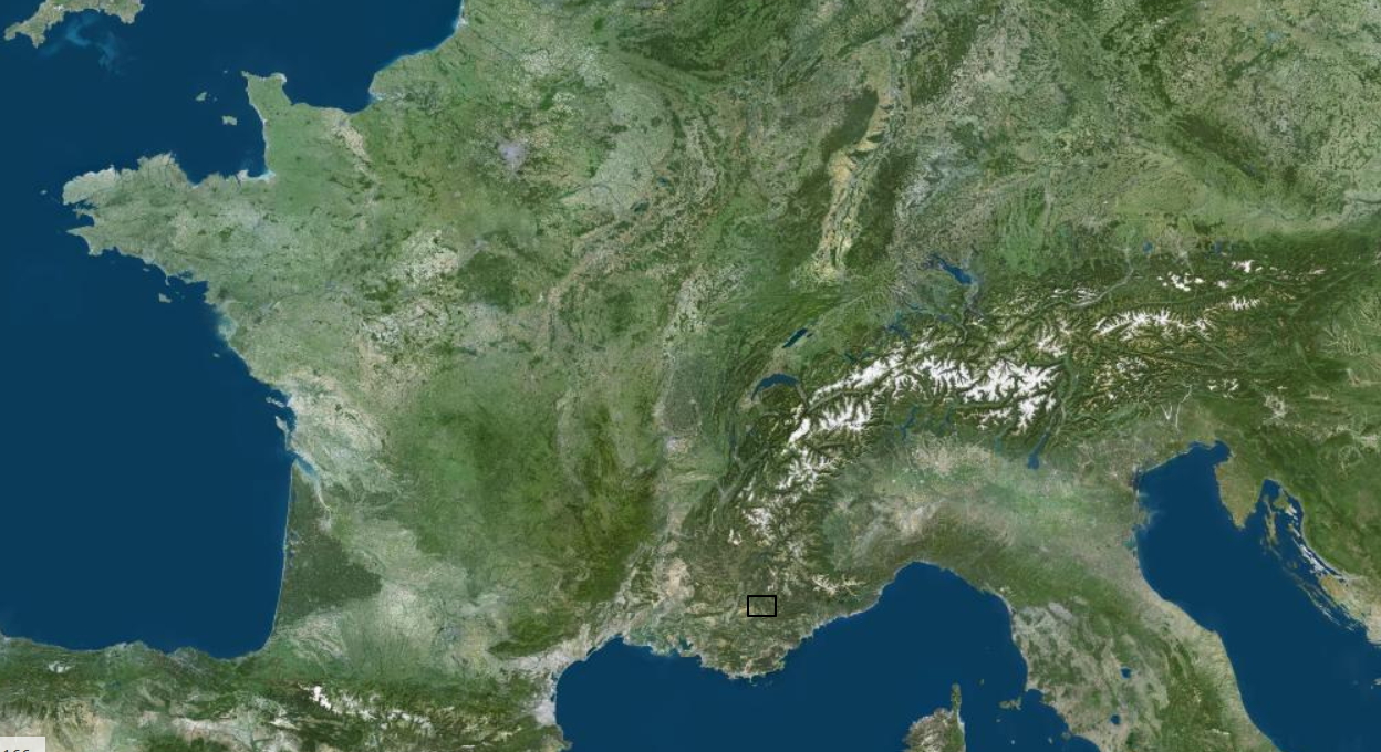
It is a small town in Alpes de Haute Provence in France. Lovely mountain zone with two village and terrain ideal for fictive provence ww2 or ww1 immersion. Situed here (see inalpes.jpg)
Next map of my project will be (see attachement bastide_mini.png). Objective will be crosse EST/WEST map (reallity match, cliff on NORTH and SOUTH). Interresting point i think is to place heavy weapon on two top height point (cliff) on top of map.
| Description: |
|
| Filesize: |
520.51 KB |
| Viewed: |
14098 Time(s) |
|
| Description: |
|
| Filesize: |
602.94 KB |
| Viewed: |
14098 Time(s) |
|
| Description: |
|
| Filesize: |
50.53 KB |
| Viewed: |
14098 Time(s) |
|
| Description: |
|
| Filesize: |
56.86 KB |
| Viewed: |
14098 Time(s) |
|
| Description: |
|
| Filesize: |
44.48 KB |
| Viewed: |
14098 Time(s) |
|
| Description: |
|
| Filesize: |
436.31 KB |
| Viewed: |
14098 Time(s) |
|
|
|
|
| Back to top |
|
| |
ScnelleMeyer
Rep: 191.3
votes: 18
|
|
| Back to top |
|
| |
mick_xe5
Rep: 19.4
votes: 5
|
| Posted: Thu Apr 06, 2017 9:45 pm Post subject: Re: My first map for GTC: Alpine Insurrection |
|
|
This image is a better illustration of the problems caused by elevation changes within a bldg. As the elev of the floor changes so does the elev of the roof 8 increments (= 4m) above the floor. This creates gaps in the roof allowing units in the bldg to see and be seen (shoot and be shot). This mistake is all too common on original as well as custom maps.

|
|
|
| Back to top |
|
| |
bux
Rep: 50.2
votes: 2
|
|
| Back to top |
|
| |
mick_xe5
Rep: 19.4
votes: 5
|
| Posted: Sat Apr 08, 2017 3:20 pm Post subject: Re: My first map for GTC: Alpine Insurrection |
|
|
| 5CC doesnt make it easy to see if your bldgs are on level elevations. Either you can see the bldg elements which dont always correspond to the roof/interior images, or you can see the elevation contours. The best method I have found is to do a general check in the elevation view. Then mouse over the bldg elements in terrain view and checktheir elev in the Coordinates window.
|
|
|
| Back to top |
|
| |
bux
Rep: 50.2
votes: 2
|
| Posted: Sun Apr 09, 2017 1:24 pm Post subject: Re: My first map for GTC: Alpine Insurrection |
|
|
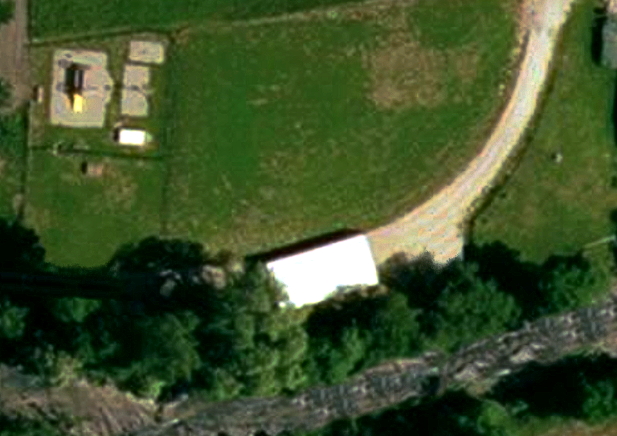
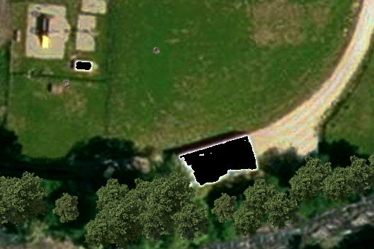
Thank's for the tips. It's usefull.
With new background image i have a problem when play map in game. Black zone are visible. They are white zone in image. Cf. attachement. Whe these black zones ? Any idea about remove them properly (i can edit image to replace white with other colour) ? Note: bmp files are exported in 32b 24b.
| Description: |
|
| Filesize: |
244.46 KB |
| Viewed: |
13991 Time(s) |
|
| Description: |
|
| Filesize: |
189.72 KB |
| Viewed: |
13991 Time(s) |
|
|
Last edited by bux on Sun Apr 09, 2017 4:09 pm; edited 1 time in total |
|
| Back to top |
|
| |