|
Posted on Sun Nov 01, 2009 10:47 pm by webmaster
|
|  |
|
|
|
No Comments Allowed for Anonymous, please register |
|
Re: Terrain Challenge #13 (Score: 1)
by pvt_Grunt on Sun Nov 01, 2009 11:43 pm
(User Info | Send a Message) | | Looks like Mars! |
|
|
Re: Terrain Challenge #13 (Score: 1)
by mooxe on Mon Nov 02, 2009 12:06 am
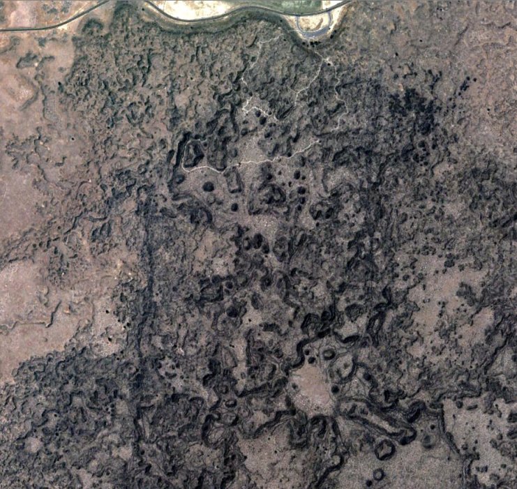
(User Info | Send a Message) http://www.closecombatseries.net | To the North there looks to be a ridge with a road on top. The dark area is either a dried up marsh or riverbed. Seems to be a walking trail coming from an observation parking lot..... hmm..
Other than it reminding me of a WW1 battlefield I have no idea where it could be. |
|
|
Re: Terrain Challenge #13: Modoc War, 1872/73 (Score: 1)
by Mafi on Mon Nov 02, 2009 10:19 pm
(User Info | Send a Message) http://closecombat2.npage.de/ | Sorry again,
I got it, it is not Mars, but USA:
http://maps.google.com/maps?f=q&source=s_q&hl=de&geocode=&q=Lava+Beds+National+Monument&sll=36.070851,-109.300532&sspn=0.018211,0.028324&ie=UTF8&hq=Lava+Beds+National+Monument&hnear=Lava+Beds+National+Monument,+Tionesta,+CA+96134&ll=41.822438,-121.502073&spn=0.015991,0.028324&t=h&z=15
Lava Beds National Monument, California, USA
An Indian War battle site (Modoc War, 1872/73):
The Modoc War, aka: Lava Beds War, Modoc Campaign (1872-1873) - Spawned by the culture clash and loss of land and lifestyle of the Modoc Indians, the natives fought the U.S. Army in southern Oregon and northern California for two years. The last Indian War to occur in California or Oregon, it resulted in the Modocs being placed on the Fort Klamath Reservation in Oregon, as well as exiling many of them to the Quapaw Agency in Oklahoma. More ...
Lava Beds National Monument - Established as a national monument chiefly for its geological and scientific value, Lava Beds is also significant as the principal battleground of the Modoc War of 1872-73. In a twisted, almost impregnable volcanic fortress that came to be known as Captain Jack's Stronghold, a handful of Modocs held off a sizable force of U.S. soldiers for six months. Modoc leader, Kintpuash know as Captain Jack, shot and killed General Edward R. S. Canby during a peace conference on April 11, 1873. Captain Jack ultimately surrendered. He and the chief conspirators of the slaying of Canby were executed.
see: http://www.legendsofamerica.com/na-indianwarsbattles-1.html |
|
|
Re: Terrain Challenge #13 (Score: 1)
by Senior_Drill on Tue Nov 03, 2009 3:32 am
(User Info | Send a Message) | Good job, Mafi! I felt sure the odd terrain would throw people off for a few days, but you pegged it in less than two. Do you have a job? :)
The area in the picture is actually higher than the fields north of the road and visitor center. It does indeed resemble a vision of Hell on Mars or the Moon. This is one of the larger lava formations that stretch all along the Cascade Mountain range from Northern California, through Oregon and Washington and well into Canada. These sorts of volcanic vents are a series of cauldera and collapsed domes (more like burst bubbles) that sometimes form natural fortifications looking like hill forts with crenelated ramparts, loop holes, bomb shelters and limited approaches. Excellent defensive terrain except for the one thing that forced the Modoc out - a lack of fresh water.
Congrats, again, Mafi! |
|
|
| |
 |
Related Links |
 |
|
|
Article Rating |
|
|
|
Options |
|
|
|