|
Posted on Mon Aug 24, 2009 4:53 am by webmaster
|
|  |
 |
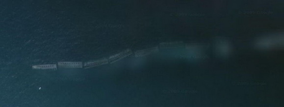
 The Terrain Challenge works like this. Find a historic place from any war on Google. Screenshot the satellite view and submit the picture to MOOXE or use the Submit News function. Each month a new one will go up. Whoever correctly answers what the image represents, wins bragging rights! Heres the first one, and this one should be easy!
Note: Solved by Mafi
|
|
 |
|
|
|
No Comments Allowed for Anonymous, please register |
|
Re: Google Terrain Challenge #1 (Score: 1)
by Mafi on Mon Aug 24, 2009 10:42 am
(User Info | Send a Message) http://closecombat2.npage.de/ | Port Winston, Normandy, North of Arromanches.
http://maps.google.de/maps?f=q&source=s_q&hl=de&q=Mulberry-Hafen,+Frankreich&sll=51.151786,10.415039&sspn=13.381124,26.499023&ie=UTF8&cd=1&geocode=Faz78AIdcFP2_w&split=0&ll=49.355321,-0.629268&spn=0.006779,0.012939&t=h&z=16 |
Re: Google Terrain Challenge #1 (Score: 1)
by AT_ActionJackson on Tue Aug 25, 2009 6:31 am
(User Info | Send a Message) | | and what do you actually see in that picture? |
]
Re: Google Terrain Challenge #1 (Score: 1)
by JaguarWolf on Tue Aug 25, 2009 10:35 am
(User Info | Send a Message) | | yeah...what the hell is that? |
]
Re: Google Terrain Challenge #1 (Score: 1)
by Marius_83 on Mon Sep 07, 2009 6:57 pm
(User Info | Send a Message) | | On this picture you see Mulberry "B" and it was the harbour assembled on Gold beach at Arromanches for use by the British and Canadian invasion forces. Its made of Concrete elements. |
]
|
|
| |
 |
Related Links |
 |
|
|
Article Rating |
|
|
|
Options |
|
|
|