|
Posted on Fri Aug 27, 2010 2:33 am by webmaster
|
|  |
|
|
|
No Comments Allowed for Anonymous, please register |
|
Re: Terrain Challenge #37 (Score: 1)
by Pzt_Kanov on Fri Aug 27, 2010 5:04 am
(User Info | Send a Message) | | isn't that Banockburn or something like that? you know, where the Scots won their independence leaded by Robert Bruce |
Re: Terrain Challenge #37 (Score: 1)
by CSO_Talorgan on Tue Oct 12, 2010 10:39 pm
(User Info | Send a Message) | Hints are requested:
http://www.closecombatseries.net/CCS/modules.php?name=Forums&file=viewtopic&t=7409
... so I can tell you that you have the right country and the right war, but you are out by one campaign!
Mind you I will wrap you over the knuckles for stating that we "won" our Independence at Bannockburn. We had always been independent in those days, but the fact needed to be reaffirmed.
;] |
]
|
|
Re: Terrain Challenge #37 (Score: 1)
by CSO_Talorgan on Mon Aug 30, 2010 3:21 am
(User Info | Send a Message) | | Am I supposed to be providing hints and clues or do I just keep Mum? |
Re: Terrain Challenge #37 (Score: 1)
by Buck_Compton on Mon Aug 30, 2010 3:45 am
(User Info | Send a Message) | You can ofcourse give som hints!
Something tells me this is Scotland that we are looking at ;) But there has been a lot of fighting over the ages ;)
cheers Buck |
]
]
Re: Terrain Challenge #37 (Score: 1)
by CSO_Talorgan on Tue Sep 14, 2010 3:44 am
(User Info | Send a Message) | OK
Just let me know if you need more info. |
]
|
|
Re: Terrain Challenge #37 (Score: 1)
by Pete on Fri Sep 03, 2010 12:12 am
(User Info | Send a Message) | | Here is what I see: a small castle on the site of a former medieval castle that must have been sieged a couple of times. The new castle has no defensive purpose and is probably newer than 17th century. It's is probably considered to be a manor rather than castle. The garden is quasi French style which might mean that it is not GB, where it also would be better maintained. The flat terrain and the garden point in the direction of Northern Europe. The river banks seem untouched and the riverbed is rocky so it's probably in Belgium, France or Germany. |
Re: Terrain Challenge #37 (Score: 1)
by pagskier on Fri Sep 03, 2010 8:22 am
(User Info | Send a Message) | | Rivers aren't rocky in England or scotland? |
]
Re: Terrain Challenge #37 (Score: 1)
by Pete on Fri Sep 03, 2010 11:24 pm
(User Info | Send a Message) | I dismissed the idea that this could be in the UK before that...
There is nothing in this image that reminds me of the UK except for the shape of the old castle. However, I have a distant recollection that Talorgan might be Scottish... |
]
|
|
Re: Terrain Challenge #37 (Score: 1)
by pagskier on Sun Oct 24, 2010 11:58 pm
(User Info | Send a Message) | | Any one has an idea??? |
|
|
Re: Terrain Challenge #37 (Score: 1)
by Buck_Compton on Sun Oct 31, 2010 9:46 pm
(User Info | Send a Message) | Ok this is a long lasting one.
what do we know:
It is somewhere in Scotland
It is the right war wich should be the 1st war of Scottish independence
This war had the following battle fields:
First Berwick – Dunbar – Lanark – Stirling Bridge – Falkirk – Roslin – Happrew – Stirling Castle – Methven – Dalrigh – Glen Trool – Loudoun Hill – Slioch – Inverurie – Buchan – Pass of Brander – Bannockburn – Connor – Kells – Skerries – Skaithmuir – Second Berwick – Faughart – Myton – Arbroath Declaration – Old Byland – Corbeil Treaty – Stanhope Park – Edinburgh-Northampton Treaty.
So Checking these out should have the right answer. So ive got something to do for the comming hours.
CHeers Buck |
Re: Terrain Challenge #37 (Score: 1)
by CSO_Talorgan on Sat Dec 11, 2010 11:49 pm
(User Info | Send a Message) | It's a siege; and maybe the longest in Scottish history.
Unfortunately it's not in the Wikipedia, but nice try!
The nearest conventional battlefield (assuming that the events of February 1305 don't count as a conventional battle) is Raploch a.k.a. Clatteringshaws; which is unfortunately not in the Wikipedia either. |
]
Re: Terrain Challenge #37 (Score: 1)
by Buck_Compton on Sun Dec 19, 2010 5:47 pm
(User Info | Send a Message) | I've noticed that talorgan. My knowledge of the scottish wars of independence dont go much further than Braveheart to be honest.
I found Raploch tough and I've been scanning all the rivers in that region. But havn't been lucky yet.
Coudnt find any info about Feb 1305 eigther btw...
Seems like i'm the only one persistent to get this one...?
CHeers |
]
Re: Terrain Challenge #37 (Score: 1)
by CSO_Talorgan on Tue Dec 21, 2010 1:42 am
(User Info | Send a Message) | The trouble is that there is more than one Raploch.
Should I be drip-feeding you(se) with clues?
The Battle of Raploch was fought at the side of a *moss*. See if that helps! |
]
Re: Terrain Challenge #37 (Score: 1)
by Buck_Compton on Wed Dec 22, 2010 7:19 am
(User Info | Send a Message) | Flooding would be more usefull I'd guess.
The battle of Raploch is the one where also Bruce's stone is located right?
Checked out that region but yet again nothing to be found. Is it just me or would I be looking at the wrong region.
Cheers |
]
Re: Terrain Challenge #37 (Score: 1)
by Pete on Fri Dec 24, 2010 7:08 pm
(User Info | Send a Message) | Man, you have managed to find the most obscure little battle in Scottish history. I have been searching on and off for the past months but I can't find anything close.
Hints provided by you: Scotland, castle siege, Wars of Independence, "events of Feb 1305" (is that a time reference?), "nearest conventional battlefield is Raploch Moss" (is that a geographical reference?), "Bannockburn" is "off by one campaign" - suggesting that it was indeed the First War of Independence. However, the Scottish Wars of Independence were not characterized by siege warfare and the few long sieges that did take place were not at this insignificant heap of boulders. So, I am about to throw in the towel. |
]
|
|
Re: Terrain Challenge #37 (Score: 1)
by Pete on Sun Dec 26, 2010 4:22 am
(User Info | Send a Message) | | Is it Buittle Castle? Captured in 1313 by Robert de Bruce. |
Re: Terrain Challenge #37 (Score: 1)
by Pete on Sun Dec 26, 2010 4:31 am
(User Info | Send a Message) | | Ok, I was still somewhat uncertain because on google maps there is no useable image but apparently you took this from Bing maps. Now I am sure that it is Buittle Castle. |
]
Re: Terrain Challenge #37 (links included) (Score: 1)
by Pete on Sun Dec 26, 2010 4:38 am
(User Info | Send a Message) | And here is some additional info: http://www.dalbeattiematters.co.uk/features.asp?ID=80
http://canmore.rcahms.gov.uk/en/site/65002/details/buittle+castle/
And I found it on this site: http://www.castleuk.net/castle_lists_scotland/84/buittlecastle.html |
]
Re: Terrain Challenge #37 (Score: 1)
by CSO_Talorgan on Wed Feb 16, 2011 12:23 am
(User Info | Send a Message) | Correct.
Well done! |
]
|
|
Re: Terrain Challenge #37 (Solved by Pete) (Score: 1)
by CSO_Talorgan on Wed Feb 16, 2011 12:49 am
(User Info | Send a Message) | I think I owe you guys an apology for not being around much while this challenge was going on. The moral is: do not set up a terrain challenge while studying for exams. By way of penance though I have written the topic up more fully. Much of this info has yet to make its way into Ph.D theses, let alone textbooks.
BUITTLE CASTLE(S)
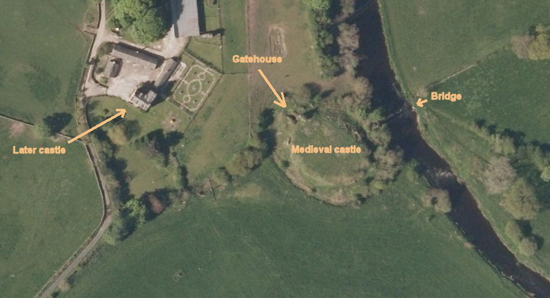
There have been at least three Buittle Castles. The first was a 12th Century, Norman, mote-and-bailey castle which would have been situated under the words "Medieval Castle" in the picture. Its mote would have been smaller than that in the picture.
Galloway was semi-independent in the 12th Century. Its rulers were desperately trying to fend off the Kings of Scots and the riverlines became military frontiers. The (rivers) Dee, Urr (pictured) and Nith have several motes on both banks. Indeed the Motte of Urr, 3 km north of Buittle is said to be the most perfectly preserved mote and bailey remnant in the country. Buittle's bailey does not show up on the satellite photos but the archeologists assure us that it was extensive. They are also confident that the first castle was destroyed by fire as they have found evidence of this in their digging. This happens to match local folklore which has it that the Normans were one arrogant bunch of bar stewards who, confident of their superior technology, tried to lord it over the locals. The locals didn't take to being lorded over and the Normans found themselves besieged in a castle with a wooden frame. The outside would have been smeared with clay or wet animal hides would have been hung over the vulnerable wood. Unfortunately, this superior technology was no match for local ingenuity and the Normans were wiped out in the inevitable fire. No quarter given!
A century later and the political landscape had changed. Galloway was no longer independent, but one of the richest provinces in the kingdom, held by the Balliol family. The Balliols were of Norman decent, but by this time the Normans were partially integrated into wider society, while still retaining International links. Needless to say they built the second castle whose larger mote is what you see in the picture. It is thought that this was finished in the 1280s soon after Edward Longshanks' castle-building programme in Wales. Buittle is not as big as Harlech or Conway or Caernarvon but shares many design features which would have been the cutting edge of technology at that time:
Construction was of stone
The basic design of the castle was a ring of (six) towers linked by a curtain wall
These towers were round, not square
The gate was flanked by twin towers
... which made the gatehouse strong enough to act as the citadel, so that a central keep was no longer required
The drawbridge was in two parts (although the archeologists have not yet figured out its exact configuration)
Resupply from the sea was possible. You know that in the Middle Ages the lowest bridging point and the highest point a sea-going ship could reach were usually the same place, which is why towns sprang up where they did? Well, Buittle was that sweet spot on the Urr. Sea level has fallen a bit since then.
The presence of a mini-Harlech in our midst does make you think though about what might have happened had we lost the war which was soon to follow ...
Eeek!
The turbulence of the 1280s and -90s probably explains why the second castle was built. The head of the Balliol family became King John and the pile of earth you see in the picture was the de-facto capital of the country for a few years immediately before events kicked off in 1295.
By 1309 the war was going very badly for the Balliol family. John, by this time the "Toom Tabard", was still alive, but was living in exile in France. Robert I finished pacifying the North that year and began his strategy of picking off enemy garrisons one by one. Buittle was allocated to his brother Edward.
It took Edward Bruce *four year
Read the rest of this comment... |
|
|
| |
 |
Related Links |
 |
|
|
Article Rating |
|
|
|
Options |
|
|
|