ScnelleMeyer

Rep: 191.3  
votes: 18
|
 Posted: Wed Aug 02, 2017 1:09 pm Post subject: Maps with contour lines Posted: Wed Aug 02, 2017 1:09 pm Post subject: Maps with contour lines |
 |
|
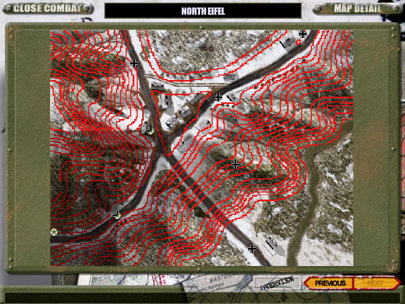
I often find it hard to judge where terrain features likes hills and valleys runs on a map. - I think the overview maps in GtC is a step forward with its yellow contour lines, although the yellow lines are somtimes hard to make out and the terrain in most of the GtC maps is flat.
In WAR and PITF for example the terrain is more varied and contour OVMs are really needed IMO.
I just did a test with contours generated from the heightmap of North Eifel of WAR and I like the results:
| Description: |
|
| Filesize: |
734.34 KB |
| Viewed: |
10715 Time(s) |
|
|
|
|
| Back to top |
|
| |
|
|
ScnelleMeyer
Rep: 191.3
votes: 18
|
| Posted: Wed Aug 02, 2017 3:51 pm Post subject: Re: Maps with contour lines |
|
|
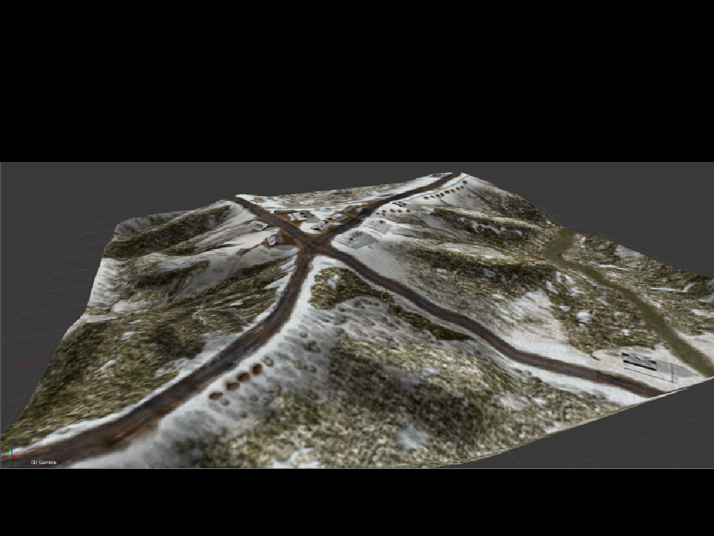
Maybe a 3d view is more usefull for some maps? - It doesnt take any longer to make these in Blender. Simple box geometry could be added for buildings.
| Description: |
|
| Filesize: |
503.64 KB |
| Viewed: |
10707 Time(s) |
|
|
|
|
| Back to top |
|
| |
Pete

Rep: 118.1
votes: 12
|
| Posted: Wed Aug 02, 2017 5:34 pm Post subject: Re: Maps with contour lines |
|
|
| Personally I don't really like the contour lines as they obstruct the general view of the terrain. I much prefer your idea of modelling the terrain in 3d.
|
Dulce Bellum Inexpertis
(War is delightful to those who have no experience of it.)
Our facebook page: https://www.facebook.com/buckandpete/
Our website: https://themodsection.net/ |
|
| Back to top |
|
| |
ScnelleMeyer
Rep: 191.3
votes: 18
|
| Posted: Wed Aug 02, 2017 6:56 pm Post subject: Re: Maps with contour lines |
|
|
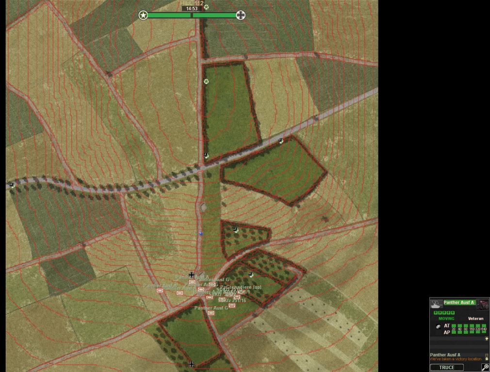
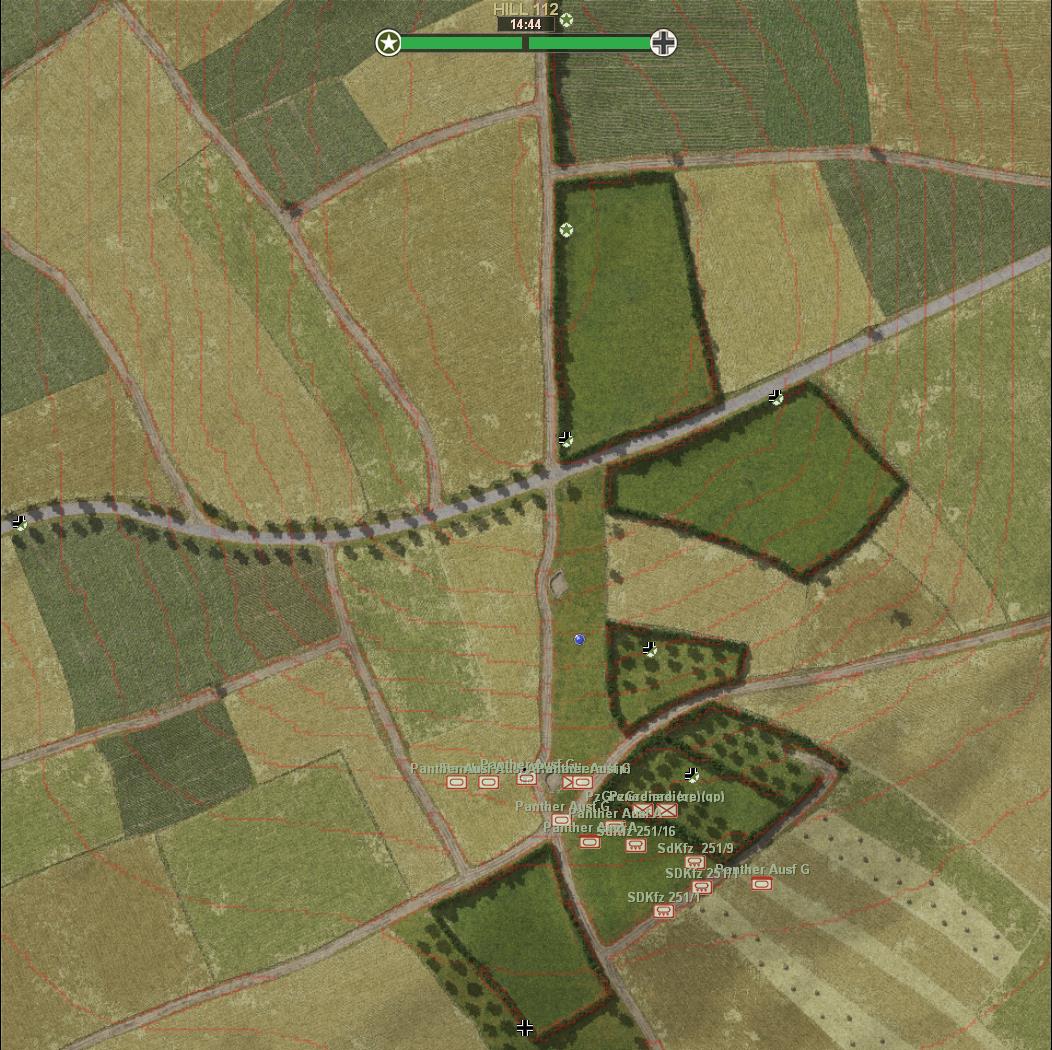
I see your point on the lines obscuring the graphics - especially with the current GtC OVMs - They are just screenshots from 5CC where the height coding has been blurred, causing more obscuration than necessary.
I would like to replace the yellow OVM contours with red ones like in the pic below. - I think they minimize the obscuration and provides better terrain awareness while playing.
- On second thought on the 3D OVMs - They will not work for positioning your troops and seeing the larger picture during battles, so I guess thats a non-starter anyway.
Even if 3D with contours could be done:D
| Description: |
| Hill 112 Updated contours |
|
| Filesize: |
125.82 KB |
| Viewed: |
10680 Time(s) |
|
| Description: |
|
| Filesize: |
80.78 KB |
| Viewed: |
10680 Time(s) |
|
|
|
|
| Back to top |
|
| |
Pete
Rep: 118.1
votes: 12
|
| Posted: Wed Aug 02, 2017 8:17 pm Post subject: Re: Maps with contour lines |
|
|
Well, the 3D image does not have to be used as the OVM. They could also be used as an extra map preview in a pdf file or so.
As for the contour lines: perhaps decreasing width and opacity would enhance visibility of the map and unit icons on it.
|
Dulce Bellum Inexpertis
(War is delightful to those who have no experience of it.)
Our facebook page: https://www.facebook.com/buckandpete/
Our website: https://themodsection.net/ |
|
| Back to top |
|
| |
ScnelleMeyer
Rep: 191.3
votes: 18
|
| Posted: Wed Aug 02, 2017 10:01 pm Post subject: Re: Maps with contour lines |
|
|
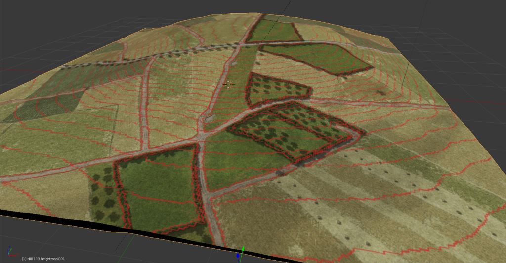
Thanks for the feedback Pete. - Tried your suggestion with the contour lines, I cant make them thinner than 2 pixels - I am lacking some kind of Photoshop trick to do it, but opacity is lowered.
I also lowered the number of contours by decreasing equidistance - Before it was 0,5m - now its 1m. This declutters the image a bit too.
| Description: |
|
| Filesize: |
203.95 KB |
| Viewed: |
10660 Time(s) |
|
|
|
|
| Back to top |
|
| |
mick_xe5

Rep: 19.4
votes: 5
|
| Posted: Thu Aug 03, 2017 11:34 pm Post subject: Re: Maps with contour lines |
|
|
| ScnelleMeyer wrote (View Post):
|
|
...Even if 3D with contours could be done:D
|
Thom did a set of quasi-3D OVMs with color coded terrain types for CC4&5.
| Description: |
|
| Filesize: |
30.95 KB |
| Viewed: |
10623 Time(s) |
|
|
|
|
| Back to top |
|
| |
Pzt_Kanov

Rep: 14.2
votes: 9
|
| Posted: Thu Aug 03, 2017 11:47 pm Post subject: Re: Maps with contour lines |
|
|
I like every pic in this thread.
A way to enable/disable would be ideal, but I guess it is not possible.
| mick_xe5 wrote (View Post):
|
| ScnelleMeyer wrote (View Post):
|
|
...Even if 3D with contours could be done:D
|
Thom did a set of quasi-3D OVMs with color coded terrain types for CC4&5.
|
Source?
|
|
|
| Back to top |
|
| |
ScnelleMeyer
Rep: 191.3
votes: 18
|
|
| Back to top |
|
| |
ScnelleMeyer
Rep: 191.3
votes: 18
|
| Posted: Fri Aug 04, 2017 5:40 pm Post subject: Re: Maps with contour lines |
|
|
Contour mod for GtC to is ready - If you want a head start on your opponent - check it out here:
http://www.closecombatseries.net/Hosted/ScnelleMeyer/Gateway%20to%20Caen/Mods/
From mod readme:
What will this mod do?
This mod will change and add map elevation contours to all GtC overview maps (OVM) that has terrain elevation changes.
These changes will also be reflected in the minimaps.
What will you see ingame?
Maps without contours are flat except for hedges.
The following 7 maps has 1m contour intervals - that is - each line represent 1m of elevation change.
9 - POINT_100
12 - COLLEVILLE
16 - GRAINVILLE-SUR-ODON
18 - MONDRAINVILLE
20 - TOURMAUVILLE
22 - GAVRUS
23 - HILL_112
These maps are marked ingame, lower right corner with "CI: 1m".
- All other maps with contours have 0,5m contour intervals to best visualize minute changes in elevation.
|
Last edited by ScnelleMeyer on Wed Jan 24, 2018 7:20 pm; edited 1 time in total |
|
| Back to top |
|
| |
platoon_michael

Rep: 56.2
votes: 25
|
| Posted: Fri Aug 04, 2017 8:01 pm Post subject: Re: Maps with contour lines |
|
|
I did the .OVM's for Wacht am Rhein to include all the trees
http://www.closecombatseries.net/Hosted/platoon_michael/WAR%20Files/Maps%20in%20Jpegs/
Your elevation isnt including.....well elevation
Yes you have the contour lines but your not depicting the actual elevation.
10Meters/20 Meters what is it?
Your really going to ask a person in Battle to remember this?..................
The following 7 maps has 1m contour intervals - that is - each line represent 1m of elevation change.
9 - POINT_100
12 - COLLEVILLE
16 - GRAINVILLE-SUR-ODON
18 - MONDRAINVILLE
20 - TOURMAUVILLE
22 - GAVRUS
23 - HILL_112
These maps are marked ingame, lower right corner with "CI: 1m".
- All other maps with contours have 0,5m contour intervals to best visualize minute changes in elevation.
|
Last edited by platoon_michael on Fri Aug 04, 2017 8:11 pm; edited 2 times in total |
|
| Back to top |
|
| |
platoon_michael
Rep: 56.2
votes: 25
|
| Posted: Fri Aug 04, 2017 8:02 pm Post subject: Re: Maps with contour lines |
|
|
Where's the rise or fall of the land?
You only painted lines
With no info
If your going to do it .....Do it Right
Display the Meters in numerical # as well as the contour lines.
|
|
|
| Back to top |
|
| |
ScnelleMeyer
Rep: 191.3
votes: 18
|
| Posted: Fri Aug 04, 2017 8:14 pm Post subject: Re: Maps with contour lines |
|
|
Hey Platoon thanks for the comments. - I would really like to see how your WAR .OVMs look like - Are they included in a mod somewhere?
I am not sure I understand what you are getting at though.
- Countour lines are what is depicted as the red lines and they do represent elevation changes like on a real map.
Most of the included .ovms have the contour intervals at 0,5 meters and a few maps are 1m. - This is explained in the readme sited above.
I opted out of including numbers for each contour as this would clutter up the view and the current elevation can always be checked by right clicking.
|
|
|
| Back to top |
|
| |
platoon_michael
Rep: 56.2
votes: 25
|
| Posted: Fri Aug 04, 2017 8:40 pm Post subject: Re: Maps with contour lines |
|
|
Yes the red lines indicate changes in elevations but they do not depict what type of elevation change.
Is it up?
Down?
I have no idea by looking at them
Because you didn't include the actual elevation for each line.
somewhere here is a thread for the .OVM's I did but I cant seem to find it.
It is included with StockMod for WAR
|
|
|
| Back to top |
|
| |
platoon_michael
Rep: 56.2
votes: 25
|
| Posted: Fri Aug 04, 2017 8:46 pm Post subject: Re: Maps with contour lines |
|
|
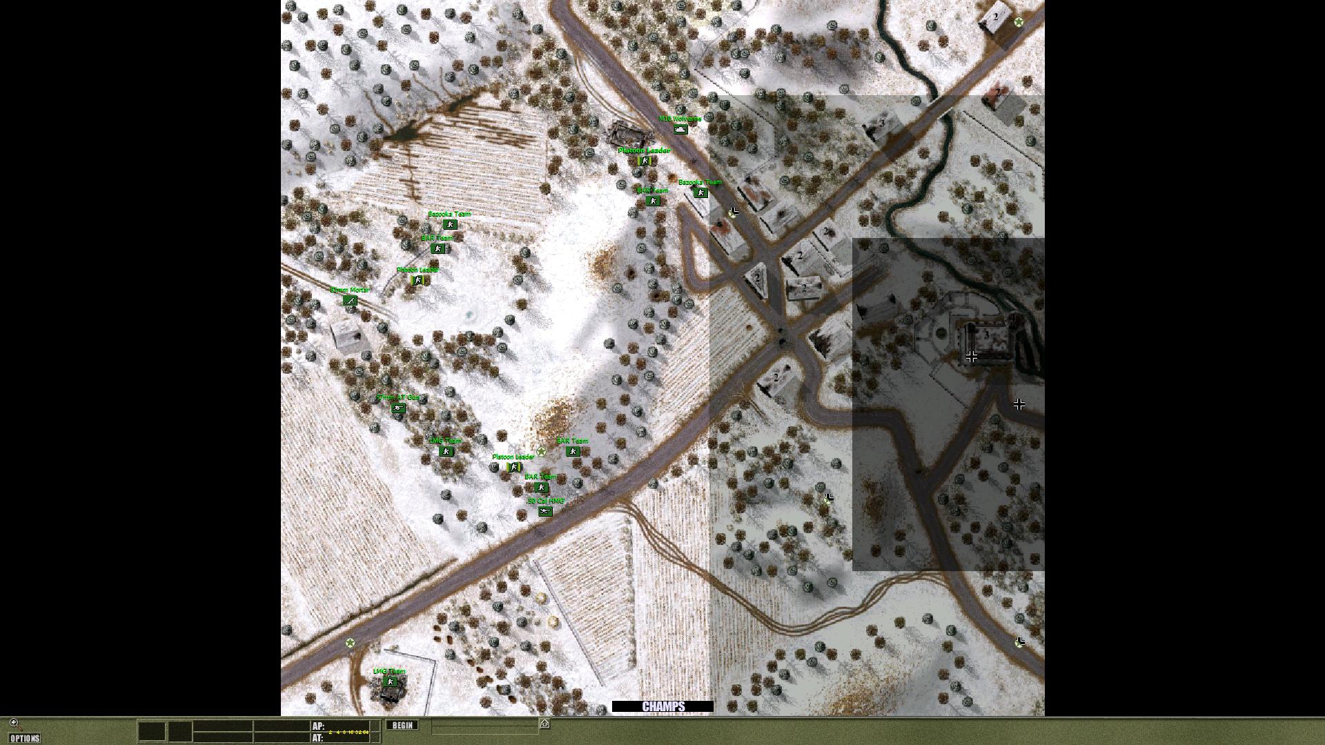
Here's a look at Champs with the Trees on the .OVM's
| Description: |
|
| Filesize: |
333.35 KB |
| Viewed: |
10575 Time(s) |
|
|
|
|
| Back to top |
|
| |
platoon_michael
Rep: 56.2
votes: 25
|
| Posted: Fri Aug 04, 2017 8:53 pm Post subject: Re: Maps with contour lines |
|
|
If you cant include the actual distance like you mentioned because of the clutter like you mentioned then why not have the distance put on the side of the .OVM?
It can be done.
Also maybe change the lines to depict a rise or fall based on the color of the lines you make.
Say Red is rise
Green depicts a slope
|
|
|
| Back to top |
|
| |
platoon_michael
Rep: 56.2
votes: 25
|
| Posted: Fri Aug 04, 2017 8:56 pm Post subject: Re: Maps with contour lines |
|
|
The .OVM can be manipulated
Out put it with 5CC or whatever your using
Then reduce it to whatever size you need to include the text you want to include
My original .OVM's were so large in size one could actually put a team Exactly where one expected them to be in game while in the .OVM.
The large size of the file for the .OVM will cause some people with slowere CPU's to crash so don't make the .OVM file to large
|
|
|
| Back to top |
|
| |
ScnelleMeyer
Rep: 191.3
votes: 18
|
| Posted: Fri Aug 04, 2017 9:04 pm Post subject: Re: Maps with contour lines |
|
|
Those .OVM - Yeah, ofc they look a lot better with trees - I have seen them as I played your mod:) - I was thinking you had some with elevations on them that I had not seen.
Btw. the ones I made for GtC also include trees in the OVMs. I might opt not to do that for PITF though.
I also saw you edited the post at the same time I was writing - It was clear to me after I read your edit.
-You would like altitude numbers by each line signifying the elevation of each line. - If thats the case I have to disapppoint you, cause thats not going to happen.
I like them as they are and have no problem understanding where the depressions and hills are, but I guess I am fortunate to have read maps a great deal in real army life:D
|
|
|
| Back to top |
|
| |
platoon_michael
Rep: 56.2
votes: 25
|
| Posted: Fri Aug 04, 2017 9:07 pm Post subject: Re: Maps with contour lines |
|
|
Also maybe change the lines to depict a rise or fall based on the color of the lines you make.
Say Red is rise
Green depicts a slope
Again your scale can be deciphered on the side of the .OVM with a little bit of Photoshop help.
|
|
|
| Back to top |
|
| |
platoon_michael
Rep: 56.2
votes: 25
|
| Posted: Fri Aug 04, 2017 9:09 pm Post subject: Re: Maps with contour lines |
|
|
I understand
Its your work........not mine
And yes I did edit my posts several times over
|
|
|
| Back to top |
|
| |